


The spirits of indigenous peoples’ forebears who nurtured their lands for many generations in the three regions of Peninsular Malaysia, Sabah and Sarawak in Malaysia must be delighted that their descendants have shown determination in safeguarding the traditional territories or wilayah adat. With its consistent advocacy for customary land rights, Jaringan Orang Asal SeMalaysia (Indigenous Peoples Network of Malaysia) or JOAS spearheaded a project on community mapping where indigenous peoples, particularly the youth, learned to trace and mark their territorial legacies, especially at a time of development threats. Initially, the matter of land mapping had to contend with blocks such as diverse understanding and interpretation of traditional land rights concepts, boundaries and delineation.
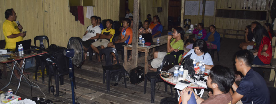
To resolve this grey area, JOAS made it possible for mapping experts to come together to define and coordinate, and unite on concepts that would be applicable to mapping activities in the three regions. The national gathering in November 2015 was a good opportunity to discuss and decide to hold a national Training of Trainers (ToT) on community mapping. They also deemed it an imperative to produce a standard training module for the trainers to use in the three regions. An interesting angle to this endeavour was the fact that many mentors had the technical expertise but were students in the field and concepts of traditional territories.
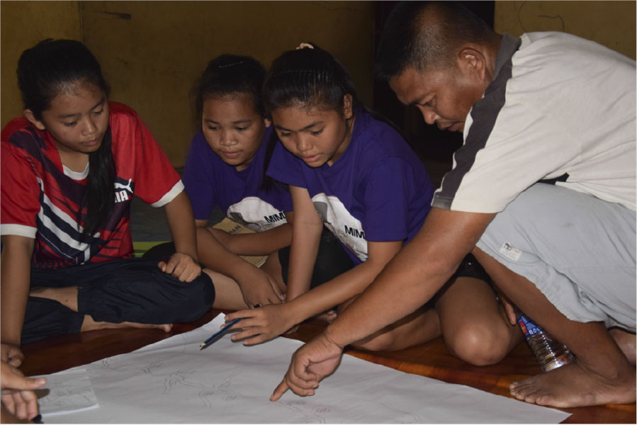
This is where indigenous knowledge was combined with technological innovation. Soon as the communities were identified where trainings and actual mapping were to be implemented, the project proceeded with mostly youth members of Belia-JOAS as participants, with direct guidance from community elders who orally shared their knowledge from memories on land uses such as sacred sites and significant landmarks. Collaborative efforts came to the fore with mapping experts from the JOAS Network tapped to conduct the trainings at the community level which eventually produced a national mapping database for the different regions to utilize. These experts were tasked to mentor and guide the newly trained youths who were also recipients of indigenous knowledge of their elders. ToT modules were tested and utilized in communities that requested training on mapping and documentation.
Crucial to this project was the ownership and security of data which had a decisive bearing on community decision-making with regard to development plans or possible conflicts. JOAS members were of the consensus that the maps were owned by the community whose Free, Prior and Informed Consent (FPIC) was needed in any publication or distribution of said maps.
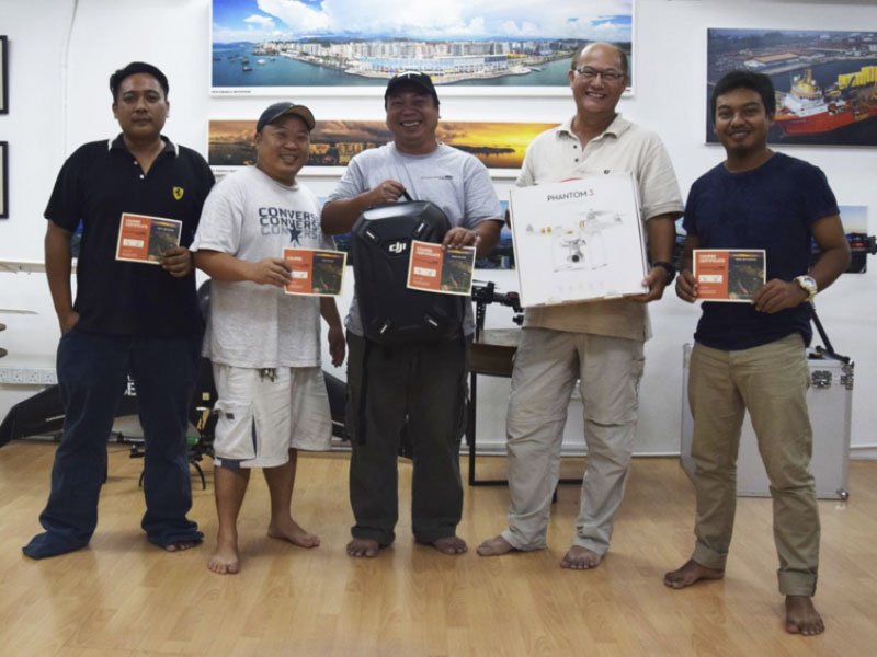
From tradition to technology, JOAS members saw these two elements in a timely merger when they decided to purchase the drone and hold trainings on the use of this device especially in inaccessibly remote areas. With the youth’s inclination and interest in technology, the Global Positioning System (GPS) instruments, Geographic Information System (GIS) softwares, cameras and videos to document traditional knowledge on territorial boundaries were a welcome development in the communities. Additionally, they learned to create sketch maps and conduct field surveys while simultaneously imbibing the wisdom of their elders.
The project enabled the indigenous youth to better understand the indigenous territories, their intangible and tangible cultural legacies, their right to land claims, and appreciate the value of learning from knowledge-holders and culture bearers, and appropriate and relevant application of technology.
The initiative of JOAS was well appreciated by Frederick Fadzli from Kampung Sungai Limo, Lundu because of the opportunity given to the youths like him to participate in the Community Mapping Training. He mused that “The training is not cheap if we were to enroll for a course in a technical institution or university. Only a few would be able to afford this. Now that we have been trained, we are confident to also train other villagers on the techniques of community mapping and use this as an important tool in our quest for recognition of our customary land rights. We who attended the training created a Whatsapp Group for us to discuss community mapping matters.”
James Nyurang from Kampung Tanjung Tepalit, Baram said that his community only wishes for development that will benefit them and will not deny them their rights. They had waited long enough. “It is very difficult to get the government to map our customary land.” In the past, they had asserted their customary land rights but the government constructed a mega-dam that supposedly ushered development to their area. Nyurang concluded: “We cannot wait for the government. So, if we have the opportunity, we will try to develop our village on our own. Community mapping is one way where we can start to plan and develop on our own.”
The project enhanced and strengthened JOAS’ relationships with their partner communities and supportive agencies. All these collaborative efforts contributed to an important milestone in as far as native customary land rights are concerned. Many other villages in other regions heard of this innovation and expressed interest in mapping their own indigenous territories as a documentation tool.
The JOAS Community Mapping team with NGO partner Pacos Trust and COAC are involved in drone training for mapping and documentation purposes. This 4-day training is divided into 2-day theoretical learning and 2-day practicum on how to fly the drone in various geophysical areas such as open space and hilly areas which is a new method using technology in field mapping.

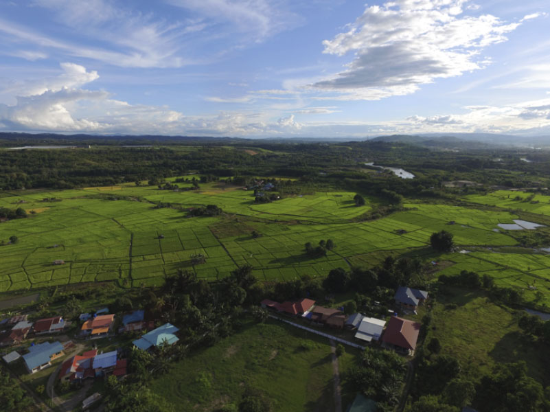
The ancestors would never have imagined the technological advancements in mapping their territories!
The project entitled “Walking with our Ancestors: Mapping Traditional Territories ” was implemented by Jaringan Orang Asal SeMalaysia (Indigenous Peoples Network of Malaysia) (JOAS) with the support of PAWANKA Fund.